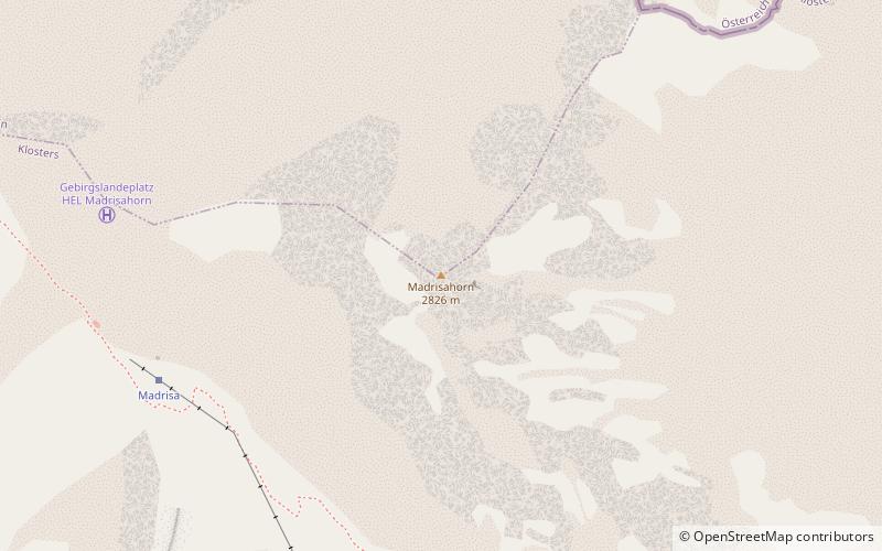
Madrisa
#340 among destinations in Switzerland
![Madrisa location map](https://tzmedia.b-cdn.net/media/images/static-maps/ch/46_9311_9_87222.jpg)
Facts and practical information
GraubündenSwitzerland
Madrisa plan & book
Unleash the traveler in you — discover the cheapest flight deals, find the perfect hotel or hostel nearby, and search for the best car rental prices. Travel at your own pace to discover new places and enjoy your journey.
Madrisa – popular in the area (distance from the attraction)
Nearby attractions include: Chalet Eugenia, Gotschnagrat, Rotbüelspitz, Casanna.
2.7 miSWinter sport, Ski areaChalet Eugenia
69 min walk • Nestled in the heart of the Swiss Alps, Chalet Eugenia is an exquisite retreat for ski enthusiasts and luxury seekers alike. This iconic chalet, located in the prestigious ski area of Klosters, offers a blend of traditional alpine charm and modern luxury, making it a...
5.1 miSNature, Natural attraction, MountainGotschnagrat
131 min walk • The Gotschnagrat is a mountain of the Plessur Alps, overlooking Klosters in the canton of Graubünden. It is a minor prominence on the ridge descending east of the Casanna. The Gotschnagrat can be reached by cable car from Klosters. In winter it is part of the large ski area between Davos and Klosters.
4.2 miENature, Natural attraction, MountainRotbüelspitz
108 min walk • The Rotbüelspitz is a mountain of the Silvretta Alps, located on the border between Austria and Switzerland. It is located north of the slightly higher Isentällispitz.
5.4 miSNature, Natural attraction, MountainCasanna
137 min walk • The Casanna is a mountain of the Plessur Alps, overlooking Serneus and Klosters in the canton of Graubünden. It lies west of the Gotschnagrat, where a cable car station is located.
4.9 miWNature, Natural attraction, MountainChrüz
125 min walk • The Chrüz is a mountain in the Rätikon range of the Alps, located west of St. Antönien in the canton of Graubünden.
3.2 miSBridgeSunniberg Bridge
83 min walk • The Sunniberg Bridge is a curved multi-span extradosed road bridge with low outward-flaring pylons above the roadway edges, designed by the renowned Swiss engineer Christian Menn and completed 1998.
5.4 miNNature, Natural attraction, MountainWiss Platte
139 min walk • The Wiss Platte is a mountain in the Rätikon range of the Alps, located on the border between Austria and Switzerland. It lies between Schruns and St. Antönien.
3.8 miNWLocalitySt. Antönien
98 min walk • St. Antönien is a Swiss village in the Prättigau and a municipality in the political district of Prättigau/Davos in the canton of Graubünden. The municipalities of St. Antönien and St. Antönien Ascharina merged on 1 January 2007 into St. Antönien.
4.7 miWLocalityKüblis
120 min walk • Küblis or Kublis is a Swiss village in the Prättigau and a municipality in the political district Prättigau/Davos Region in the canton of Graubünden.
5.7 miNHiking, Alpine hutCarschinahütte
145 min walk • The Carschinahütte is a refuge of the Rätia Section of the Swiss Alpine Club, in the Rätikon mountain group, in the Swiss canton of Graubünden. It is located north of St. Antönien at an altitude of 2236 m above sea level below the Sulzfluh, in a...