Lower Neponset River Trail, Boston

Gallery (1)
Map
Map
Facts and practical information
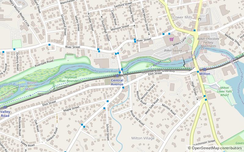
The Lower Neponset River Trail is a 2.4-mile-long rail trail running along the Neponset River in the Dorchester section of Boston, Massachusetts. It roughly follows the path of the eastern part of the Dorchester and Milton Branch Railroad from the Port Norfolk neighborhood in Dorchester to the Central Avenue T Station in Milton, passing through Pope John Paul II Park, the Neponset Marshes, and the Lower Mills area. ()
Length: 2.4 miSeason: All yearCoordinates: 42°16'12"N, 71°4'24"W
Address
Milton (Columbine Cliffs)Boston
ContactAdd
Social media
Add
Getting there by public transportation
Public transportation stops near this location
- Metro
- Bus
- Light rail
- Train
 Metro
Metro
- Calculate routeCentral Avenue 1 min walk
- Calculate routeMilton 8 min walk
- Calculate routeValley Road 12 min walk
- Calculate routeButler 15 min walk
- Calculate routeCentral Ave @ Central Ave Station 1 min walk
- Calculate routeCentral Ave @ Maple St 3 min walk
- Calculate routeRiver St @ Wichita Ter 6 min walk
- Calculate routeMorton Street 25 min walk
- Calculate routeAshmont/Peabody Square 29 min walk
Maps MBTA Subway
MBTA SubwayDay trips
Lower Neponset River Trail – popular in the area (distance from the attraction)
Nearby attractions include: Milton Centre Historic District, Captain Robert Bennet Forbes House, Parish of All Saints Ashmont, Pierce House.


Frequently Asked Questions (FAQ)
Which popular attractions are close to Lower Neponset River Trail?
Nearby attractions include Lower Mills, Boston (8 min walk), Gov. Thomas Hutchinson's Ha-ha, Milton (11 min walk), Boston Consumptives Hospital, Boston (13 min walk), Milton Hill Historic District, Milton (14 min walk).
How to get to Lower Neponset River Trail by public transport?
The nearest stations to Lower Neponset River Trail:
Light rail
Bus
Train
Metro
Light rail
- Central Avenue • Lines: M (1 min walk)
- Milton • Lines: M (8 min walk)
Bus
- Central Ave @ Central Ave Station • Lines: 240, 240 inbound, 240 outbound, 240-1 inbound, 240-1 outbound, 240-9 inbound, 240-9 outbound (1 min walk)
- Central Ave @ Maple St • Lines: 240 outbound, 240-1 outbound, 240-9 outbound (3 min walk)
Train
- Morton Street (25 min walk)
Metro
- Ashmont/Peabody Square • Lines: Red (29 min walk)