St. Helena's Church, New York City
Map
Facts and practical information
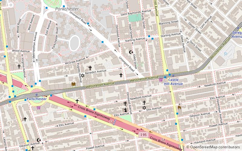
The Church of St. Helena is a parish of the Roman Catholic Church in the Archdiocese of New York. Its parish church is located at the intersection of Olmstead Avenue and Benedict Avenue, Bronx, New York City, in the Unionport neighborhood. It was established in 1940, and the church building was built in the same year and was designed by the prominent architectural firm of Eggers & Higgins. ()
Coordinates: 40°50'3"N, 73°51'18"W
Address
1315 Olmstead AvenueEast Bronx (Parkchester)New York City
ContactAdd
Social media
Add
Getting there by public transportation
Public transportation stops near this location
- Metro
- Bus
 Metro
Metro
- Calculate routeCastle Hill Avenue 5 min walk
- Calculate routeParkchester 9 min walk
- Calculate routeZerega Avenue 12 min walk
- Calculate routeEast Tremont Avenue & Dogwood Drive 16 min walk
- Calculate routeUnionport Road & East Tremont Avenue 17 min walk
- Calculate routeEast Tremont Avenue & Unionport Road 17 min walk
Maps SubwayMaps
 Manhattan Buses
SubwayMapsManhattan BusesDay trips


Frequently Asked Questions (FAQ)
Which popular attractions are close to St. Helena's Church?
Nearby attractions include Parkchester, New York City (12 min walk), St. Raymond's Church, New York City (14 min walk), Blessed Sacrament Church, New York City (17 min walk), Huntington Free Library and Reading Room, New York City (19 min walk).
How to get to St. Helena's Church by public transport?
The nearest stations to St. Helena's Church:
Metro
Bus
Metro
- Castle Hill Avenue • Lines: <6>, 6 (5 min walk)
- Parkchester • Lines: <6>, 6 (9 min walk)
Bus
- East Tremont Avenue & Dogwood Drive • Lines: Bx40, Bx42 (16 min walk)
- Unionport Road & East Tremont Avenue • Lines: Bx22 (17 min walk)