Scharteberg
#1769 among destinations in Germany


Facts and practical information
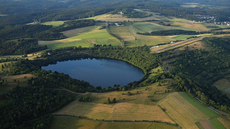
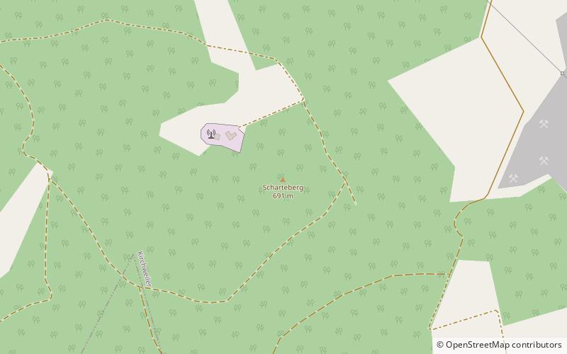
The Scharteberg is a mountain, 691.4 metres high, near Kirchweiler in the district of Vulkaneifel and is one of the highest peaks in the Eifel region of Germany. On the summit is the Eifel Transmitter which belongs to SWR and is used for FM radio and television. ()
Rhineland-PalatinateGermany
Scharteberg plan & book
Unleash the traveler in you — discover the cheapest flight deals, find the perfect hotel or hostel nearby, and search for the best car rental prices. Travel at your own pace to discover new places and enjoy your journey.
Scharteberg – popular in the area (distance from the attraction)
Nearby attractions include: Weinfelder Maar, Kasselburg, Lissingen Castle, Hoher List Observatory.
5.2 miSENature, Natural attraction, LakeWeinfelder Maar, Schalkenmehren
132 min walk • Nestled in the idyllic Eifel region of Germany, the Weinfelder Maar is a stunning natural wonder that beckons visitors to the tranquil town of Schalkenmehren. This picturesque maar, or volcanic crater lake, is one of the three Dauner Maare, often referred to as the...
3.3 miNWForts and castles, Gothic architectureKasselburg, Pelm
85 min walk • Nestled in the quaint town of Pelm in Germany, Kasselburg is a historic gem that beckons travelers with its medieval allure. This impressive castle complex, dating back to the 12th century, stands as a testament to the architectural ingenuity of the era.
5 miWForts and castles, Gothic architectureLissingen Castle, Gerolstein
128 min walk • Nestled in the verdant hills of Gerolstein, Germany, Lissingen Castle stands as a testament to the region's rich medieval history. This historical landmark, with its robust stone walls and picturesque setting, invites visitors to step back in time and explore the...
5.7 miSEMuseum, Observatories and planetariumsHoher List Observatory, Schalkenmehren
147 min walk • Hoher List Observatorium is an Observatory located on the Hoher List mountain about 60 km south-west of the city of Bonn, close to the town of Daun in the Eifel...
5.7 miSENature, Natural attraction, LakeSchalkenmehrener Maar, Schalkenmehren
147 min walk • The Schalkenmehrener Maar is a maar roughly 3 kilometres southeast of the town of Daun in the Eifel in the German state of Rhineland-Palatinate.
4.7 miSENature, Natural attraction, LakeGemündener Maar
119 min walk • Gemündener Maar, nestled in the scenic Eifel region of Germany, is a tranquil lake formed in the crater of an extinct volcano. This picturesque body of water is one of the three Daun Maar lakes, known collectively as the "Eyes of the Eifel" due to their unique...
4 miWNature, Natural attraction, VolcanoPapenkaule, Gerolstein
102 min walk • The Papenkaule is a dry crater of a volcano that was active about 10,000 years ago. It lies north of Gerolstein in the Eifel mountains in Germany.
5.7 miSENature, Natural attraction, MountainHoher List, Schalkenmehren
145 min walk • The Hoher List is a stratovolcano, 549.1 m above sea level, near the town of Daun in the Eifel region. The hill is in the county of Vulkaneifel in the German state of Rhineland-Palatinate.
3.7 miEScience museum, Natural history museum, MuseumVolcano Museum, Daun
94 min walk • The Volcano Museum in the old district administrative office in Daun, Germany, was set up as an extension of the existing 'geopaths' at Hillesheim, Manderscheid and Gerolstein and is part of the Volcanic Eifel Nature and Geopark.
1.7 miSNature, Natural attraction, MountainNerother Kopf, Neroth
44 min walk • The Nerother Kopf is the conical hill of an extinct volcano near Neroth in the Eifel mountains. It is 651.7 m above sea level and situated in the county of Vulkaneifel in the German state of Rhineland-Palatinate.
4 miNWNature, Natural attraction, MountainRockeskyller Kopf
103 min walk • The Rockeskyller Kopf near Rockeskyll in the county of Vulkaneifel in the German state of Rhineland-Palatinate is a hill, 554.6 m above sea level, in the Eifel mountains.