Mosque in Sendling, Munich
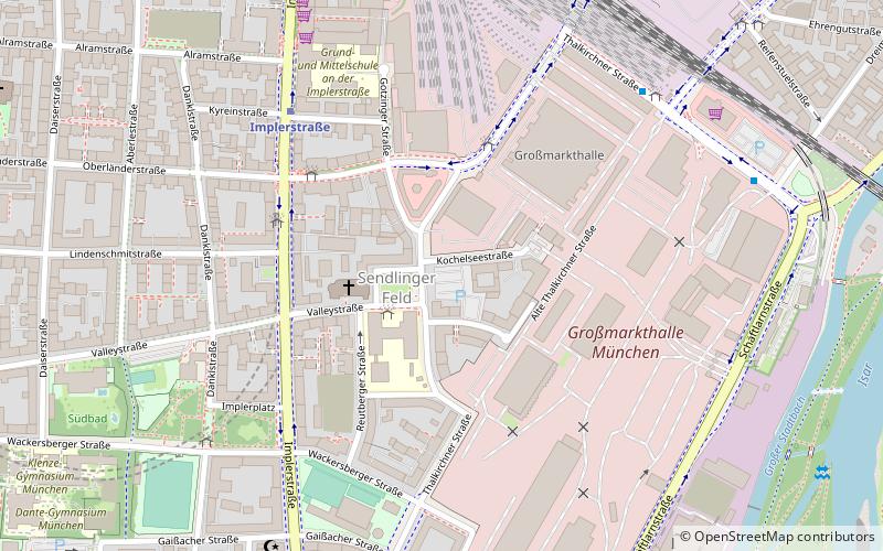
Map
Facts and practical information
The Mosque in Sendling, Munich, Germany, is situated on Schanzenbachstraße. The mosque has existed there since 1989 as an Islamic prayer house mainly for Turkish Muslims. ()
Address
Sendling (Sendlinger Feld)Munich
ContactAdd
Social media
Add
Getting there by public transportation
Public transportation stops near this location
- Metro
- Bus
- Tram
- Train
 Metro
Metro
- Calculate routeGotzinger Platz 2 min walk
- Calculate routeGroßmarkthalle 4 min walk
- Calculate routeImplerstraße 4 min walk
- Calculate routeLagerhausstraße 7 min walk
- Calculate routeImplerstraße 6 min walk
- Calculate routeBrudermühlstraße 11 min walk
- Calculate routePoccistraße 14 min walk
- Calculate routeHarras 16 min walk
- Calculate routeBrudermühlstraße 11 min walk
- Calculate routeHarras 18 min walk
- Calculate routeGoetheplatz 21 min walk
- Calculate routeMittersendling 26 min walk
- Calculate routeTegernseer Landstraße 32 min walk
- Calculate routeWettersteinplatz 32 min walk
- Calculate routeKurzstraße 33 min walk
- Calculate routeSendlinger Tor 33 min walk
Day trips


Frequently Asked Questions (FAQ)
Which popular attractions are close to Mosque in Sendling?
Nearby attractions include Wholesale Market Munich, Munich (5 min walk), Lindwurmstraße, Munich (12 min walk), Sendling, Munich (14 min walk), Wittelsbacherbrücke, Munich (21 min walk).
How to get to Mosque in Sendling by public transport?
The nearest stations to Mosque in Sendling:
Bus
Metro
Train
Tram
Bus
- Gotzinger Platz • Lines: 132 (2 min walk)
- Großmarkthalle • Lines: 132 (4 min walk)
Metro
- Implerstraße • Lines: U3, U6 (6 min walk)
- Brudermühlstraße • Lines: U3 (11 min walk)
Train
- Brudermühlstraße (11 min walk)
- Harras (18 min walk)
Tram
- Tegernseer Landstraße • Lines: 25, N27 (32 min walk)
- Wettersteinplatz • Lines: 25, N27 (32 min walk)