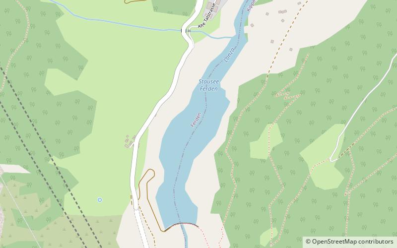
Stausee Ferden
#1558 among destinations in Switzerland

Facts and practical information
Stausee Ferden is a reservoir on the Lonza river at Ferden, Valais, Switzerland. Its surface area is 10.6 ha. ()
ValaisSwitzerland
Stausee Ferden plan & book
Unleash the traveler in you — discover the cheapest flight deals, find the perfect hotel or hostel nearby, and search for the best car rental prices. Travel at your own pace to discover new places and enjoy your journey.
Stausee Ferden – popular in the area (distance from the attraction)
Nearby attractions include: Bietschhorn, Schwarzsee, Balmhorn, Torrenthorn.
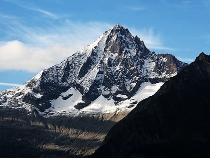
4.5 miE , Natural attraction, MountainBietschhorn, Lötschental
114 min walk • The Bietschhorn is a mountain in canton Wallis to the south of the Bernese Alps in Switzerland. The northeast and southern slopes of the mountain are part of the Jungfrau-Aletsch Protected Area listed as a UNESCO World Heritage Site that also includes the Jungfrau and the Aletsch Glacier.
 Natural attraction, Lake
Schwarzsee, Lötschental
122 min walk • Schwarzsee is a lake at Blatten in the Lötschental valley in the canton of Valais, Switzerland.
 Forested mountain with alpine huts
Balmhorn
102 min walk • The Balmhorn is a mountain in the Bernese Alps in Switzerland. Its summit ridge lies on the border between the cantons of Berne and the Valais.
 Nature, Natural attraction, Mountain
Torrenthorn
97 min walk • The Torrenthorn is a mountain of the Bernese Alps, overlooking Leukerbad in the canton of Valais. It lies south of the Majinghorn. In winter the Torrenthorn is part of a ski area.
 Alpine peak and skiing/mountaineering spot
Altels
120 min walk • The Altels is a mountain of the Bernese Alps, located on the border between the Swiss cantons of Bern and Valais. It is situated in the Balmhorn massif, approximately halfway between Kandersteg and Leukerbad.
 Peak with skiing and mountaineering
Hockenhorn
71 min walk • The Hockenhorn is a mountain of the Bernese Alps, located on the border between the Swiss cantons of Bern and Valais. Its summit is 3,293 metres high and lies between the upper Kandertal and the Lötschental.
 Nature, Natural attraction, Mountain
Rinderhorn
133 min walk • The Rinderhorn is a mountain of the Bernese Alps, overlooking Leukerbad in the canton of Valais. It lies east of Gemmi Pass on the chain culminating at the Balmhorn.
 Nature, Natural attraction, Mountain
Niwen
72 min walk • The Niwen is a mountain of the Bernese Alps, overlooking the Rhone in the upper canton of Valais. It lies in the massif that separates the valley of Leukerbad from the lower Lötschental and that culminates at the Ferdenrothorn.
 Natural attraction, Mountain
Birghorn, Lötschental
120 min walk • The Birghorn is a mountain of the Bernese Alps, located on the border between the Swiss cantons of Bern and Valais. It lies on the range connecting the Lötschen Pass from the Tschingelhorn, separating the upper Gasterntal from the Lötschental.
 Nature, Natural attraction, Mountain
Ferdenrothorn
71 min walk • The Ferdenrothorn is a mountain of the Bernese Alps, located between Leukerbad and Ferden in the canton of Valais. It lies south of the Balmhorn and overlooks the Lötschen Pass on its north side. Its east side shows well marked folds.
 Natural attraction, Mountain
Sackhorn, Lötschental
93 min walk • The Sackhorn is a mountain of the Bernese Alps, located on the border between the Swiss cantons of Bern and Valais. It lies on the range east of the Lötschen Pass, between the upper Gasterntal and the Lötschental.


