Leckihorn
#958 among destinations in Switzerland
Facts and practical information
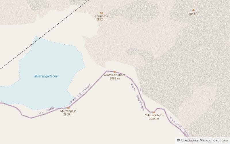
The Leckihorn is a mountain in the Lepontine Alps, located on the border between the cantons of Valais and Uri. Its summit is also named Gross Leckihorn to distinguish it from a lower summit named Chli Leckihorn. ()
ValaisSwitzerland
Leckihorn – popular in the area (distance from the attraction)
Nearby attractions include: Swiss Alps, Gotthard Pass, Pizzo Rotondo, Lago di Lucendro.
4.9 miEWinter sport, Ski areaSwiss Alps
125 min walk • Nestled in the heart of Europe, the Swiss Alps stand as an iconic testament to the pristine beauty and thrilling adventure that Switzerland has to offer. Known for their majestic peaks, the Alps provide a premier ski area that attracts winter sports enthusiasts from...
5.1 miENatural attraction, Mountain, ParkGotthard Pass, Airolo
131 min walk • The Gotthard Pass or St. Gotthard Pass at 2,106 m is a mountain pass in the Alps traversing the Saint-Gotthard Massif and connecting northern with southern Switzerland.
1.3 miSNature, Natural attraction, MountainPizzo Rotondo
32 min walk • Pizzo Rotondo is a mountain in the Lepontine Alps. At 3,190 metres above sea level, it is the highest mountain lying on the border between the cantons of Ticino and Valais, as well as the highest summit of the Lepontine Alps lying between Nufenen Pass and Lukmanier Pass.
4.1 miNENature, Natural attraction, LakeLago di Lucendro
104 min walk • Lago di Lucendo is a reservoir at the St. Gotthard Pass in the municipality of Airolo of the canton of Ticino, Switzerland. The dam Lucendro with a height of 73 m was completed in 1947.
2.6 miENature, Natural attraction, MountainPizzo Lucendro
68 min walk • Pizzo Lucendro is a 2,963-metre-high mountain in the Lepontine Alps, located on the border between the cantons of Uri and Ticino. It overlooks St. Gotthard Pass and Lake Lucendro on its east side.
2 miSNature, Natural attraction, MountainChüebodenhorn
51 min walk • The Chüebodenhorn is a 3,070 metres high mountain in the Lepontine Alps, located on the border between the cantons of Valais and Ticino.
1.9 miWNature, Natural attraction, MountainMuttenhorn
49 min walk • The Muttenhorn is a mountain in the Lepontine Alps, located on the border between the cantons of Valais and Uri. At 3,099 metres above sea level, it overlooks the south side of Furka Pass.
4.4 miSWNature, Natural attraction, MountainPizzo Gallina
114 min walk • Pizzo Gallina is a 3,061-metre-high mountain in the Lepontine Alps of Switzerland, overlooking the Nufenen Pass. Administratively, the summit is located on the border between the municipality of Obergoms, to the north-west and in the canton of Valais, and the municipality of Bedretto, to the south-east and in the canton of Ticino.
4 miENature, Natural attraction, MountainFibbia
102 min walk • The Fibbia is a 2,738 m high mountain in the Swiss Lepontine Alps; the Fibbia overlooks the Gotthard Pass, in the canton of Ticino.
0.7 miSENature, Natural attraction, MountainWitenwasserenstock
19 min walk • The Witenwasserenstock is a peak between the Swiss cantons of Valais and Uri, located in the Lepontine Alps. Close to the summit lies the tripoint border between the cantons of Valais, Uri and Ticino and the triple watershed of the Rhine, Po and Rhône basins.
4.4 miNWNature, Natural attraction, MountainKlein Furkahorn
113 min walk • The Klein Furkahorn is a mountain of the Urner Alps, overlooking the Furka Pass on the border between the Swiss cantons of Valais and Uri. It lies near the southern end of the Galenstock-Gross Furkahorn chain, east of the Rhone Glacier. From the Furka Pass a trail leads to its summit.