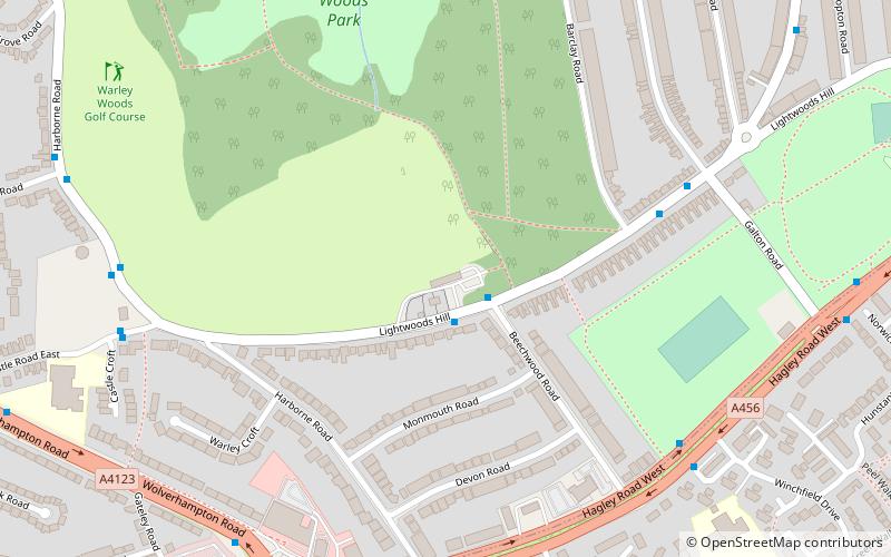
Warley Woods, Birmingham
Map
Facts and practical information
Warley College, originally called Warley College of Technology, was a college of further and higher education which served the vicinity of Oldbury in the West Midlands of England. It was formed in 1968 by the amalgamation of Oldbury College of Further Education and Chance Technical College in Smethwick and named in accordance with the recently created County Borough of Warley. It was located on the main Wolverhampton – Birmingham road. But now has moved both sites to pound road, now named as 'Oldbury Academy' ()
Coordinates: 52°28'11"N, 1°58'53"W
Address
The Pavilion, 101 Lightwoods Hill, SmethwickSandwell (Abbey)Birmingham
Contact
Social media
Add
Getting there by public transportation
Public transportation stops near this location
- Bus
 Bus
Bus
- Calculate routeHagley Road West / Wolverhampton Rd 7 min walk
- Calculate routeBs 13 min walk
- Calculate routeBv 14 min walk
Day trips


Frequently Asked Questions (FAQ)
Which popular attractions are close to Warley Woods?
Nearby attractions include Warley Woods, Birmingham (6 min walk), Lightwoods Park, Birmingham (8 min walk), Sandwell, Birmingham (17 min walk), St Faith and St Laurence's Church, Birmingham (18 min walk).
How to get to Warley Woods by public transport?
The nearest stations to Warley Woods:
Bus
Bus
- Hagley Road West / Wolverhampton Rd • Lines: X8 (7 min walk)
- Bs • Lines: 400, X8 (13 min walk)