San Francisco Public Library - Ingleside Branch, San Francisco

Facts and practical information
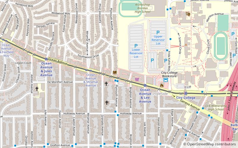
San Francisco Public Library - Ingleside Branch (address: 1298 Ocean Ave) is a place located in San Francisco (California state) and belongs to the category of library.
It is situated at an altitude of 282 feet, and its geographical coordinates are 37°43'27"N latitude and 122°27'22"W longitude.
Planning a visit to this place, one can easily and conveniently get there by public transportation. San Francisco Public Library - Ingleside Branch is a short distance from the following public transport stations: Plymouth Avenue & Ocean Avenue (bus, 1 min walk), Ocean Avenue & Lee Avenue (light rail, 3 min walk), Balboa Park (metro, 13 min walk), Broad Street & Plymouth Avenue (train, 20 min walk), Mission Street & Geneva Avenue (trolleybus, 25 min walk).
Among other places and attractions worth visiting in the area are: City College of San Francisco (universities and schools, 8 min walk), Rams Stadium (sport venue, 11 min walk), Balboa Park (park, 16 min walk).
- Metro
- Bus
- Trolleybus
- Light rail
- Train
 Metro
Metro
- Calculate routePlymouth Avenue & Ocean Avenue 1 min walk
- Calculate routeCity College Terminal 5 min walk
- Calculate routeCity College Bookstore 6 min walk
- Calculate routeOcean Avenue & Lee Avenue 3 min walk
- Calculate routeBalboa Park 13 min walk
- Calculate routeBroad Street & Plymouth Avenue 20 min walk
- Calculate routeRandolph Street & Arch Street 24 min walk
- Calculate routeMission Street & Geneva Avenue 25 min walk
 Muni Metro


Frequently Asked Questions (FAQ)
Which popular attractions are close to San Francisco Public Library - Ingleside Branch?
How to get to San Francisco Public Library - Ingleside Branch by public transport?
Bus
- Plymouth Avenue & Ocean Avenue • Lines: 29 (1 min walk)
- City College Terminal • Lines: 8 (5 min walk)
Light rail
- Ocean Avenue & Lee Avenue • Lines: K (3 min walk)
Metro
- Balboa Park • Lines: Blue, Green, Red, Yellow (13 min walk)
Train
- Broad Street & Plymouth Avenue (20 min walk)
- Randolph Street & Arch Street (24 min walk)
Trolleybus
- Mission Street & Geneva Avenue • Lines: 14 (25 min walk)