Mosher, Baltimore

Gallery (1)
Map
Map
Facts and practical information
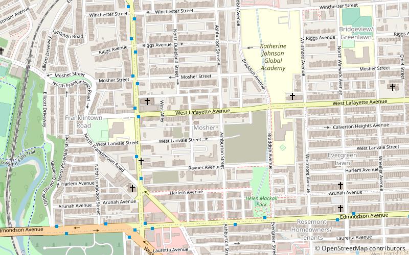
Mosher is a neighborhood in the western part of Baltimore, Maryland. Its boundaries are the north side of Edmondson Avenue, the west side of Braddish Avenue, the east side of Poplar Grove, and the south side of Riggs Avenue. The neighborhood lies in the vicinity of Walbrook Junction, Coppin State University, Sandtown-Winchester, and Edmondson Village. Mosher is one of several neighborhoods that resisted the development of the "Road to Nowhere", now designated as US 40, along the Franklin Avenue corridor. The area was historically segregated, and largely occupied by European Americans, but transitioned during the early 1950s to become a predominantly African American area. ()
Coordinates: 39°17'51"N, 76°39'44"W
Address
Western Baltimore (Mosher)Baltimore
ContactAdd
Social media
Add
Getting there by public transportation
Public transportation stops near this location
- Metro
- Bus
- Train
 Metro
Metro
- Calculate routeWest Baltimore 15 min walk
- Calculate routeWest Baltimore 16 min walk
- Calculate routeNorth Avenue & Bentalou Street Eastbound 24 min walk
- Calculate routeBentalou Street & North Avenue Northbound 24 min walk
- Calculate routePenn–North 35 min walk
Day trips


Frequently Asked Questions (FAQ)
Which popular attractions are close to Mosher?
Nearby attractions include Edmondson Avenue Historic District, Baltimore (2 min walk), Hebrew Orphan Asylum, Baltimore (2 min walk), Bridgeview/Greenlawn, Baltimore (11 min walk), Midtown-Edmondson, Baltimore (18 min walk).
How to get to Mosher by public transport?
The nearest stations to Mosher:
Train
Bus
Metro
Train
- West Baltimore (15 min walk)
Bus
- West Baltimore • Lines: 77, 78, Or, Pk (16 min walk)
- North Avenue & Bentalou Street Eastbound • Lines: Gd (24 min walk)
Metro
- Penn–North • Lines: M (35 min walk)