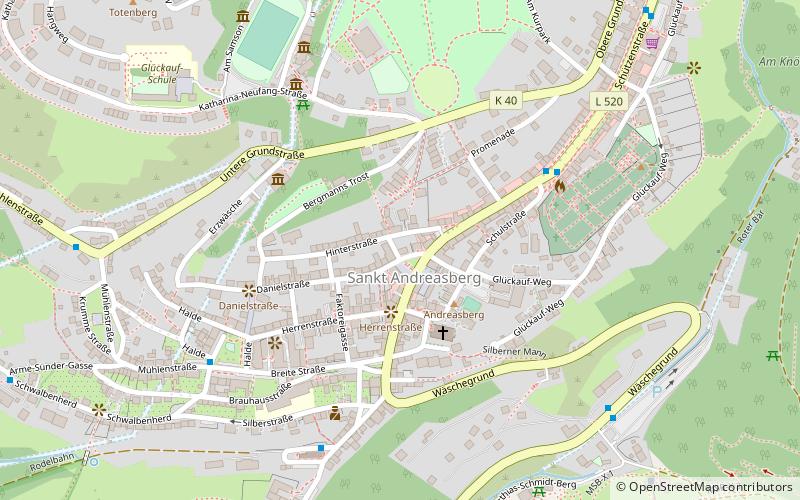
Sankt Andreasberg
Map
Gallery
Facts and practical information
Day trips
Sankt Andreasberg – popular in the area (distance from the attraction)
Nearby attractions include: Oderteich, Achtermannshöhe, Oder Dam, Stöberhai.
#1086 among destinations in Germany
Unleash the traveler in you — discover the cheapest flight deals, find the perfect hotel or hostel nearby, and search for the best car rental prices. Travel at your own pace to discover new places and enjoy your journey.
Nearby attractions include: Oderteich, Achtermannshöhe, Oder Dam, Stöberhai.
108 min walk • The Oderteich is an historic reservoir about seven kilometres northeast of Sankt Andreasberg in the Upper Harz in central Germany. It was built by miners from St.
105 min walk • At 925 m above sea level, the Achtermannshöhe in the Harz National Park is the third highest mountain in Lower Saxony and the fourth highest in the Harz mountains.
98 min walk • The Oder Dam is a dam in the Harz mountains of Germany. It lies above Bad Lauterberg in the district of Göttingen in Lower Saxony and impounds the river Oder. The dam went into service in 1934 after taking 3 years to build. The owner and operator of the Oder Dam is the Harzwasserwerke.
104 min walk • The Stöberhai is a mountain the Harz highlands in Central Germany, immediately south of the Oder Dam and northwest of Wieda. At a height of 720 m above sea level it is the highest mountain in the South Harz.
80 min walk • The Sonnenberg is a ski resort in the Upper Harz surrounded by the Harz National Park. The settlement of the same name located there is part of the borough of Sankt Andreasberg.
23 min walk • The Jordanshöhe is a mountain, roughly 723 m above sea level, in the Harz in central Germany. It lies north of the town of Sankt Andreasberg in the district of Goslar in Lower Saxony. To the west is the Kuppe.
108 min walk • Hasselkopf is a mountain on the southern periphery of Braunlage, Germany. It is 612 m high. The hill is mostly covered in grass and undeveloped, but its northern slope has a short ski lift and can be used for downhill skiing in the winter months.
66 min walk • The Hahnenklee Crags are a rock formation west of Braunlage in the district of Goslar in Lower Saxony, Germany. They consist of hornfels.
58 min walk • At 893 metres above sea level, the Rehberg in the Harz mountains is the fourth highest mountain in the German state of Lower Saxony, and the fifth-highest in the Harz.
105 min walk • Auf dem Acker is a mountain ridge up to 865.1 metres high, which is located in the southwestern part of the Harz mountains in Lower Saxony.
58 min walk • The Koboltstaler Köpfe are a group of three mountains, that rise southwest of Sankt Andreasberg and east of Sieber in the district of Göttingen in Lower Saxony.
Where to next? Visit Lower Saxony region page or discover the top tourist attractions in Germany.