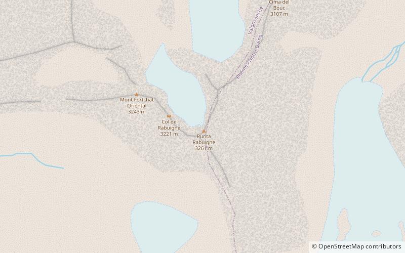
Punta Rabuigne
#4265 among destinations in Italy


Facts and practical information
The Rabuigne Peak is a 3,261 m above sea level mountain in the Grande Sassière-Tsanteleina Range in the Graian Alps. It is located in the Aosta Valley.
Aosta ValleyItaly
Punta Rabuigne plan & book
Unleash the traveler in you — discover the cheapest flight deals, find the perfect hotel or hostel nearby, and search for the best car rental prices. Travel at your own pace to discover new places and enjoy your journey.
Punta Rabuigne – popular in the area (distance from the attraction)
Nearby attractions include: Refuge Jean-Frédéric Benevolo, Mont Tout Blanc, Punta Leynir, Punta Bes.
4 miSHiking, Rest area, Alpine hutRefuge Jean-Frédéric Benevolo, Rhêmes-Notre-Dame
103 min walk • Refuge Gian Federico Benevolo is a refuge in the Alps in Aosta Valley, Italy. The setting at 2285m is beautiful, and within a six hours walk from Rifugio Citta di Chivasso to the East and Rifugio Bezzi to the West.
4.8 miSEMountainMont Tout Blanc, Rhêmes-Notre-Dame
122 min walk • The Mont Tout Blanc is a 3,438.2 metres high mountain belonging to the Italian side of Graian Alps.
4.8 miSEMountainPunta Leynir, Rhêmes-Notre-Dame
122 min walk • The Punta Leynir is a 3,238 metres high mountain belonging to the Italian side of Graian Alps.
5.1 miSEMountainPunta Bes, Rhêmes-Notre-Dame
129 min walk • The Punta Bes is a 3,177 metres high mountain belonging to the Italian side of Graian Alps.
6.2 miSWNature, Natural attraction, MountainAiguille de la Grande Sassière
158 min walk • Aiguille de la Grande Sassière is a mountain in the Graian Alps, on the boundary between the Aosta Valley and the French department of Savoie. On the Italian side, it marks the end of the Valgrisenche; on the French side it commands the Val d'Isère.
3.8 miSWHiking, Alpine hutRifugio Mario Bezzi
98 min walk • The Mario Bezzi refuge is an alpine refuge located in Valgrisenche in the Aosta Valley. It is named after the zoologist Mario Bezzi. It is located in the upper Valgrisenche at Alpe Vaudet.
1.5 miNWHiking, Alpine hutChalet de l'Epée
38 min walk • Chalet de l'Épée is an alpine hut located in Épée-des-Plontains, Valgrisenche, in the Graian Alps.
4.3 miNWHiking, Alpine hutRefuge des Anges au Morion
111 min walk • Refuge des Anges au Morion is a refuge in the Alps in Italy.
6.3 miNWNature, Natural attraction, MountainTesta del Rutor
161 min walk • Testa del Rutor or Tête du Ruitor is a mountain of the Graian Alps in Aosta Valley, north-western Italy. It is the highest summit of the Rutor-Léchaud Group, lying roughly between the Mont Blanc Massif and the Vanoise Massif.
6.5 miSENature, Natural attraction, Natural featureGraian Alps
167 min walk • The Graian Alps are a mountain range in the western part of the Alps.
0.7 miSNature, Natural attraction, MountainGrande Rousse
19 min walk • The Grande Rousse is a mountain of the Graian Alps in Aosta Valley, Italy. It is the culminating point of a ridge separating the Rhêmes and the Valgrisenche valleys. It was first climbed in 1864.