Catacomb of Pontian, Rome
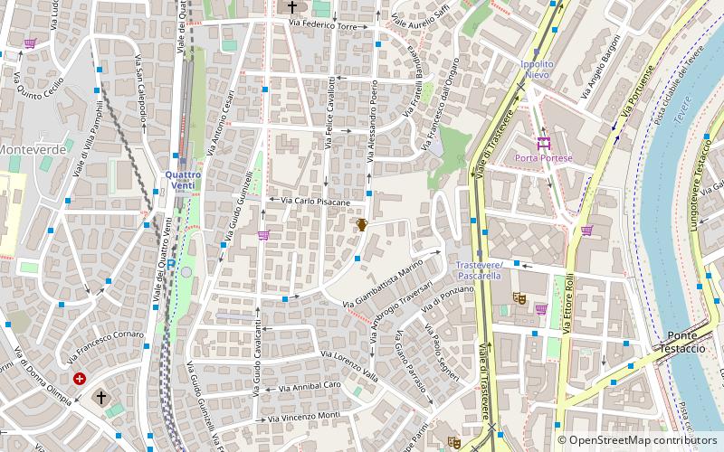
Map
Facts and practical information
The Catacomb of Pontian is one of the catacombs of Rome on the Via Portuensis, notable for containing the original tombs of Pope Anastasius I and his son Pope Innocent I. The Catacomb was discovered by famed Italian explorer Antonio Bosio in 1618. ()
Address
GianicolenseRome
ContactAdd
Social media
Add
Getting there by public transportation
Public transportation stops near this location
- Metro
- Bus
- Tram
- Light rail
- Train
- Ferry
 Metro
Metro
- Calculate routePoerio/Marino 2 min walk
- Calculate routePoerio/dall'Ongaro 2 min walk
- Calculate routePoerio 4 min walk
- Calculate routeTrastevere/Pascarella 4 min walk
- Calculate routeTrastevere/Pascarella 4 min walk
- Calculate routeIppolito Nievo 8 min walk
- Calculate routeStazione Trastevere 8 min walk
- Calculate routeGianicolense/Ponte Bianco 11 min walk
- Calculate routeQuattro Venti 6 min walk
- Calculate routeRoma Trastevere 10 min walk
- Calculate routeRoma Porta San Paolo 25 min walk
- Calculate routePiramide 27 min walk
- Calculate routeGarbatella 33 min walk
- Calculate routeIsola Tiberina 29 min walk
Maps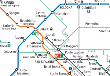 Metro / Tram / Rail
Metro / Tram / RailDay trips


Frequently Asked Questions (FAQ)
Which popular attractions are close to Catacomb of Pontian?
Nearby attractions include Ponte Testaccio, Rome (11 min walk), Lungotevere Testaccio, Rome (12 min walk), Villa Sciarra, Rome (12 min walk), Ponte dell'Industria, Rome (16 min walk).
How to get to Catacomb of Pontian by public transport?
The nearest stations to Catacomb of Pontian:
Bus
Tram
Train
Light rail
Metro
Ferry
Bus
- Poerio/Marino • Lines: 75 (2 min walk)
- Poerio/dall'Ongaro • Lines: 75, n19 (2 min walk)
Tram
- Trastevere/Pascarella • Lines: 8 (4 min walk)
- Ippolito Nievo • Lines: 8 (8 min walk)
Train
- Quattro Venti (6 min walk)
- Roma Trastevere (10 min walk)
Light rail
- Roma Porta San Paolo • Lines: Fc2 (25 min walk)
Metro
- Piramide • Lines: B (27 min walk)
- Garbatella • Lines: B (33 min walk)
Ferry
- Isola Tiberina • Lines: Battelli di Roma (29 min walk)