Smerek, Bieszczady National Park
#9 among attractions in Bieszczady National Park
![Smerek location map](https://tzmedia.b-cdn.net/media/images/static-maps/pl/49_1867_22_4793.jpg)
Facts and practical information
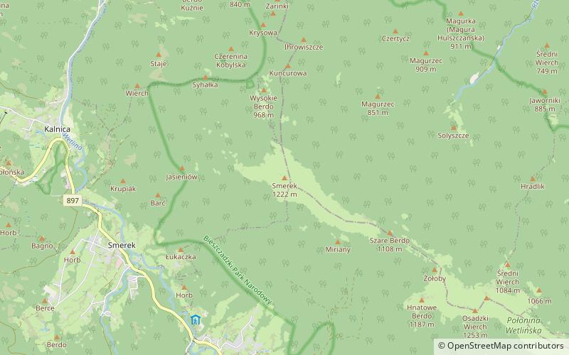
Smerek - a peak in the Western Bieszczady. This is the name under which it is most often described on maps and in guidebooks. On some maps, however, it is described as Wysoka.
Bieszczady National Park Poland
Smerek – popular in the area (distance from the attraction)
Nearby attractions include: Cerkiew pw. Świętego Męczennicy Paraskewii, Kościół pw. Świętego Mikołaja, Hasiakowa Skała, Osadzki Wierch.
7.2 miNWChurchCerkiew pw. Świętego Męczennicy Paraskewii
185 min walk • Church of St. Martyr Paraskeva in Lopienka - Greek Catholic church, built in the village of Lopienka.
6 miNEChurchKościół pw. Świętego Mikołaja
153 min walk • St. Nicholas Church in Chmiel - a former Greek Catholic wooden church, built in 1906 in the village of Chmiel.
3.8 miSENature, Natural attraction, MountainHasiakowa Skała, Bieszczady National Park
98 min walk • Hasiakowa Skała - the easternmost peak of Połonina Wetlińska in the Bieszczady Mountains, located north of the Wyżna Pass and west of the Prowcza Creek valley. A side ridge of Jawornik and Dwernik Kamień, extending northward from the peak to the...
2.5 miSENature, Natural attraction, MountainOsadzki Wierch, Bieszczady National Park
65 min walk • Osadzki Wierch - the second highest and highest trail accessible peak in the Połonina Wetlinska range in the Western Bieszczady Mountains.
6.8 miSENature, Natural attraction, MountainMała Rawka, Bieszczady National Park
174 min walk • Mala Rawka - a mountain that is the culmination of the Dział ridge. It is located near the village Ustrzyki Górne in the Western Bieszczady. To the northeast diverges the ridge, through the Wyżniańska Pass running towards Połonina Caryńska.
2 miSENature, Natural attraction, MountainHnatowe Berdo, Bieszczady National Park
52 min walk • Hnatowe Berdo - a not very prominent culmination of Połonina Wetlinska in the Western Bieszczady Mountains. It is located west of Osadzki Wierch, as the end of a short side ridge. The summit part is covered by the forest.
6.6 miSENature, Natural attraction, MountainWyżniański Wierch, Bieszczady National Park
167 min walk • Wyżniański Peak - a peak in the Western Bieszczady Mountains, located southwest of the Wyżniańska Pass. It is a gentle, grassy and not high hill located between the lofty massifs of Połonina Caryńska and Mała Rawka.
2.6 miSENature, Natural attraction, MountainRoh, Bieszczady National Park
66 min walk • Roh - the highest peak of Połonina Wetlińska in the Western Bieszczady. The peak is the culmination of the grehoty-covered ridge located between the Silver Pass separating it from Osadzki Wierch and Hasiakowa Skała and is situated in its...
1.3 miSENature, Natural attraction, MountainSzare Berdo, Bieszczady National Park
33 min walk • Szare Berdo - a peak in the Western Bieszczady Mountains. Szare Berdo is the lowest, unexplored peak of the Połonina Wetlinska massif. It rises between Osadzki Wierch and Smerek, from which it is separated by the Mieczyslaw Orlowicz Pass.
3.7 miSNature, Natural attraction, MountainJawornik, Bieszczady National Park
95 min walk • Javornik - a peak in the side ridge of the border range of the Western Bieszczady Mountains, diverging from Riabia Skała to the north. It rises 400 m above the village of Wetlina. It is completely covered with beech forest.
3.8 miSETrail, Hiking, HostelSchronisko BdPN Chatka Puchatka, Bieszczady National Park
97 min walk • Tourist Shelter BdPN "Chatka Puchatka" on Połonina Wetlińska - the highest located shelter and accommodation in the Bieszczady Mountains, once called "Tavern". Located at an altitude of 1228 m, and according to other sources 1231 m on Połonina...