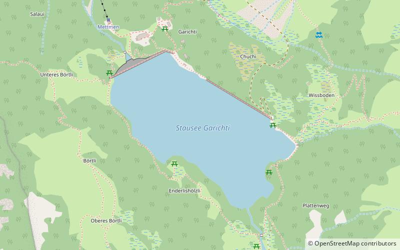
Garichtisee
#234 among destinations in Switzerland

Facts and practical information
Garichtisee is a reservoir on Mettmenalp above Schwanden in the Canton of Glarus, Switzerland. The lake's surface area is 16 ha. ()
GlarusSwitzerland
Garichtisee plan & book
Unleash the traveler in you — discover the cheapest flight deals, find the perfect hotel or hostel nearby, and search for the best car rental prices. Travel at your own pace to discover new places and enjoy your journey.
Garichtisee – popular in the area (distance from the attraction)
Nearby attractions include: Oberblegisee, Glarus Süd, Glärnisch, Kärpf.
 Nature, Natural attraction, Lake
Oberblegisee
113 min walk • Oberblegisee is a lake in the Canton of Glarus, Switzerland. It is located at an elevation of 1,422 metres, above the village of Luchsingen and below the peaks of Glärnisch. Its surface area is 0.17 square kilometres.
 Area
AreaGlarus Süd, Glarus
75 min walk • Glarus Süd is a municipality in the Swiss canton of Glarus. It comprises the upper Linth valley, and the entire Sernf valley, and includes the villages of Betschwanden, Braunwald, Diesbach, Elm, Engi, Haslen, Hätzingen, Leuggelbach, Linthal, Luchsingen, Matt, Mitlödi, Nidfurn, Rüti, Schwanden, Schwändi and Sool.
 Nature, Natural attraction, Mountain
Glärnisch
144 min walk • The Glärnisch is a mountain massif of the Schwyz Alps, overlooking the valley of the Linth in the Swiss canton of Glarus. It consists of several summits, of which the highest, Bächistock, is 2,915 metres above sea level.
 Nature, Natural attraction, Mountain
Kärpf
70 min walk • The Kärpf is a mountain in the Glarus Alps, at an elevation of 2,794 m. The Kärpf is the highest point of the massif lying north of Richetli Pass.
 Nature, Natural attraction, Mountain
Laaxer Stöckli
180 min walk • The Laaxer Stöckli is a 2,898 metre-high mountain of the Glarus Alps, located on the border between the cantons of Glarus and Graubünden in Eastern Switzerland. It lies approximately halfway between the Vorab and Piz Segnas.
 Nature, Natural attraction, Mountain
Vorder Glärnisch
137 min walk • The Vorder Glärnisch is a mountain of the Schwyzer Alps, overlooking the valley of the Linth in the canton of Glarus. It lies north-east of the higher Glärnisch. Unlike its higher neighbour, the Vorder Glärnisch can be ascended via a trail on its north-west side.
 Nature, Natural attraction, Mountain
Gufelstock
135 min walk • The Gufelstock is a mountain of the Glarus Alps, overlooking Schwanden in the canton of Glarus. The border with the canton of St. Gallen runs on the northern base of the mountain.
 Nature, Natural attraction, Mountain
Bützistock
157 min walk • The Bützistock is a mountain of the Glarus Alps. It lies on the border between the cantons of Glarus and St. Gallen in Eastern Switzerland. The top is 2,496 m above sea level or 513 meters above the surrounding terrain. The width at the base is 18 km.
 Nature, Natural attraction, Lake
Chüebodensee
54 min walk • Chüebodensee is a lake above Elm in the Canton of Glarus, Switzerland. Its surface area is 1.4 ha. There are about 8 km of well established trails around the lake. The lake is within the Glarner Freiberg wildlife preserve.
 Village
Braunwald
130 min walk • Braunwald is a car-free resort village in the municipality of Glarus Süd and canton of Glarus in Switzerland.
 Hiking, Alpine hut, Hostel
Leglerhütte SAC
56 min walk • Leglerhütte is located at 2273 meters above sea level in the Glarus Alps at the foot of the Kärpf massif in the canton of Glarus. It is continuously staffed in summer and on weekends in winter and is an important base for tours in the Freiberg...


