Chüebodensee
#1537 among destinations in Switzerland
Facts and practical information
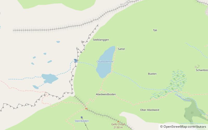
Chüebodensee is a lake above Elm in the Canton of Glarus, Switzerland. Its surface area is 1.4 ha. There are about 8 km of well established trails around the lake. The lake is within the Glarner Freiberg wildlife preserve. ()
GlarusSwitzerland
Chüebodensee plan & book
Unleash the traveler in you — discover the cheapest flight deals, find the perfect hotel or hostel nearby, and search for the best car rental prices. Travel at your own pace to discover new places and enjoy your journey.
Chüebodensee – popular in the area (distance from the attraction)
Nearby attractions include: Garichtisee, Vorab, Glarus Süd, Kärpf.
- 2.1 miNWNature, Natural attraction, Lake
Garichtisee
54 min walk • Garichtisee is a reservoir on Mettmenalp above Schwanden in the Canton of Glarus, Switzerland. The lake's surface area is 16 ha.
- 4.5 miSNature, Natural attraction, Mountain
Vorab
114 min walk • The Vorab is a mountain of the Glarus Alps, located on the border between the cantons of Glarus and Graubünden. The summit is also named Bündner Vorab to distinguish it from a lower summit named Glarner Vorab.
- 4.9 miNWArea
Glarus Süd, Glarus
126 min walk • Glarus Süd is a municipality in the Swiss canton of Glarus. It comprises the upper Linth valley, and the entire Sernf valley, and includes the villages of Betschwanden, Braunwald, Diesbach, Elm, Engi, Haslen, Hätzingen, Leuggelbach, Linthal, Luchsingen, Matt, Mitlödi, Nidfurn, Rüti, Schwanden, Schwändi and Sool.
- 2.4 miSWNature, Natural attraction, Mountain
Kärpf
61 min walk • The Kärpf is a mountain in the Glarus Alps, at an elevation of 2,794 m. The Kärpf is the highest point of the massif lying north of Richetli Pass.
- 7.2 miSWNature, Natural attraction, Lake
Muttsee
183 min walk • Muttsee is a reservoir in the Canton of Glarus, Switzerland. Its surface area is 42 ha. It is used to supply water for the hydroelectric Linth–Limmern Power Stations.
- 4.9 miSENature, Natural attraction, Mountain
Laaxer Stöckli
126 min walk • The Laaxer Stöckli is a 2,898 metre-high mountain of the Glarus Alps, located on the border between the cantons of Glarus and Graubünden in Eastern Switzerland. It lies approximately halfway between the Vorab and Piz Segnas.
- 5.4 miSWNature, Natural attraction, Mountain
Hausstock
137 min walk • The Hausstock is a mountain in the Glarus Alps, at an elevation of 3,158 m on the border between the cantons of Glarus and Graubünden. It overlooks the valleys of Linth and Sernf rivers in Glarus, and the valley of the Vorderrhein river in Graubünden.
- 5.6 miENature, Natural attraction, Mountain
Piz Sardona
143 min walk • Piz Sardona is a mountain in the Glarus Alps, on the border between the cantons Glarus and St. Gallen. The 3,056 metre high mountain overlooks the valleys of Elm and Calfeisen.
- 5.3 miENature, Natural attraction, Mountain
Piz Segnas
137 min walk • Piz Segnas is a mountain in the Glarus Alps, located on the border between the cantons of Glarus and Graubünden. Piz Sardona is on the same ridge to the north, from where the Trinserhorn or Piz Dolf lies to the southeast.
- 7.2 miSWNature, Natural attraction, Mountain
Nüschenstock
183 min walk • The Nüschenstock is a mountain of the Glarus Alps, located south of Linthal in canton of Glarus. On its eastern side it overlooks the Muttsee.
- 6.5 miSWNature, Natural attraction, Mountain
Ruchi
166 min walk • The Ruchi is a mountain in the Glarus Alps, located at an elevation of 3,107 m on the border between the Swiss cantons of Glarus and Graubünden. It overlooks the Muttsee on its west side from where a trail leads to the summit. On its south-east side lies a small glacier, the Glatscher da Gavirolas.