Sir Jack Hayward Training Ground, Wolverhampton
Map
Facts and practical information
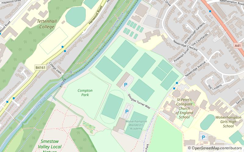
The Sir Jack Hayward Training Ground is the training ground and academy base of English football club Wolverhampton Wanderers Football Club. It is located in the Compton area of Wolverhampton. ()
Opened: 2005 (21 years ago)Coordinates: 52°35'33"N, 2°9'47"W
Address
ParkWolverhampton
ContactAdd
Social media
Add
Getting there by public transportation
Public transportation stops near this location
- Bus
 Bus
Bus
- Calculate routeCompton Park / Compton Park Schools 5 min walk
- Calculate routeHenwood Rd / College View 5 min walk
- Calculate routeTettenhall Rd / New Hampton Rd West 9 min walk
Day trips


Frequently Asked Questions (FAQ)
Which popular attractions are close to Sir Jack Hayward Training Ground?
Nearby attractions include Tettenhall, Wolverhampton (12 min walk), Tettenhall Green, Wolverhampton (17 min walk), St Andrew's Church, Wolverhampton (21 min walk), Merridale, Wolverhampton (21 min walk).
How to get to Sir Jack Hayward Training Ground by public transport?
The nearest stations to Sir Jack Hayward Training Ground:
Bus
Bus
- Compton Park / Compton Park Schools • Lines: 711, 713, 714, 794 (5 min walk)
- Henwood Rd / College View • Lines: 62, 62A (5 min walk)