Plattenhausenriegel
#1302 among destinations in Germany
![Plattenhausenriegel location map](https://tzmedia.b-cdn.net/media/images/static-maps/de/48_964_13_4503.jpg)
Facts and practical information
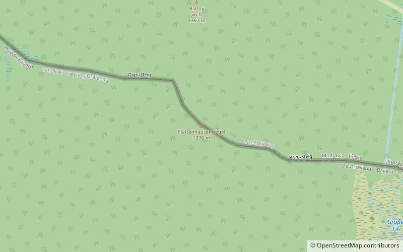
Plattenhausenriegel is a mountain of the Bavarian Forest; and Bohemian Forest, on the border between Germany and the Czech Republic. ()
BavariaGermany
Plattenhausenriegel plan & book
Unleash the traveler in you — discover the cheapest flight deals, find the perfect hotel or hostel nearby, and search for the best car rental prices. Travel at your own pace to discover new places and enjoy your journey.
Plattenhausenriegel – popular in the area (distance from the attraction)
Nearby attractions include: Lusen, Frauenau Dam, Kanzel, Latschensee.
3.1 miSENature, Natural attraction, MountainLusen, Bavarian Forest National Park
79 min walk • Lusen is a mountain in Bavaria and in the Plzeň Region of with a peak of 1373 metres. It is the sixth-highest mountain in the Bavarian Forest National Park/Bohemian Forest, behind the Großer Rachel, Kleiner Rachel, Kleiner Arber, Plattenhausenriegel and Großer Arber.
5.8 miNWLakeFrauenau Dam, Frauenau
148 min walk • The Frauenau Dam in the Bavarian Forest, was built in 1983 to ensure the drinking water supply to large parts of Lower Bavaria.
6.4 miSEMountainKanzel, Bavarian Forest National Park
165 min walk • Kanzel is a mountain of Bavaria, Germany.
4.9 miNWNature, Natural attraction, LakeLatschensee, Bavarian Forest National Park
125 min walk • Latschensee is a lake in the Bavarian Forest, Bavaria, Germany. It lies at an elevation of 1150 meters and has a surface area of 0.1 hectares.
3 miWNature, Natural attraction, MountainGroßer Rachel
76 min walk • The Großer Rachel or Great Rachel is a mountain, 1,452 m above sea level; it is the second highest summit in the Bavarian Forest and Bohemian Forest after the Großer Arber and the highest mountain in the Bavarian Forest National Park.
2.3 miWNature, Natural attraction, LakeRachelsee
60 min walk • Rachelsee is a lake in the Bavarian Forest, Bavaria, Germany. It lies at an elevation of 1071 metres and has a surface area of 5.7 hectares.
5.4 miSTourist information, Botanical gardenBotanischer Garten der Nationalpark Bayerischer Wald, Grafenau
137 min walk • The Botanischer Garten der Nationalpark Bayerischer Wald is a botanical garden located adjacent to the Hans-Eisenmann-Haus visitor center in the Nationalpark Bayerischer Wald at Böhmstraße 35, Neuschönau, Bavaria, Germany.
3.4 miENature, Natural attraction, MountainSteinfleckberg, Bavarian Forest National Park
86 min walk • Steinfleckberg is a mountain of Bavaria, Germany.
3.1 miSEMountainWaldhäuserriegel, Bavarian Forest National Park
80 min walk • Waldhäuserriegel is a mountain of Bavaria, Germany. It is located northeast of the city of Grafenau and lies in the protected Core Zone of the Bavarian Forest National Park, only two kilometers from the border between Germany and the Czech Republic.
3.5 miWNature, Natural attraction, MountainKleiner Rachel, Bavarian Forest National Park
90 min walk • Kleiner Rachel is a mountain of Bavaria, Germany.
3.8 miSENature, Natural attraction, MountainHoher Filzberg, Bavarian Forest National Park
96 min walk • Hoher Filzberg is a mountain of Bavaria, Germany.