St. Johann in Ranui - S. Giovanni in Ranui
#3081 among destinations in Italy
![blank map](https://tzassets.b-cdn.net/static/img/blank-map-colors-sm.png)
![St. Johann in Ranui - S. Giovanni in Ranui](https://tzmedia.b-cdn.net/media/images/it/place/gallery/medium/9bcccedaa3a8c89eaf6b54ff081aaf2c.jpg)
Facts and practical information
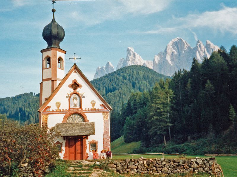
The Church of St. John in Ranui is a church located in Funes, in the hamlet of St. Magdalena.
S. Giovanni, 2Val di Funes 39040 Trentino-South TyrolItaly
St. Johann in Ranui - S. Giovanni in Ranui plan & book
Unleash the traveler in you — discover the cheapest flight deals, find the perfect hotel or hostel nearby, and search for the best car rental prices. Travel at your own pace to discover new places and enjoy your journey.
St. Johann in Ranui - S. Giovanni in Ranui – popular in the area (distance from the attraction)
Nearby attractions include: Parish church of Urtijëi, Museum Gherdëina, Peitlerkofel, Regensburger Hütte - Rifugio Firenze.
4.8 miSWChurchParish church of Urtijëi, Ortisei
123 min walk • The Parish Church of Urtijëi located in the town of Urtijëi in Val Gardena in South Tyrol, Italy is dedicated to the Epiphany and to Saint Ulrich.
4.8 miSWNatural history museum, MuseumMuseum Gherdëina, Ortisei
124 min walk • The Gherdëina Local Heritage Museum was opened in the Cësa di Ladins in Urtijëi, in northernmost Italy, in 1960. The building is the seat of the Union di Ladins de Gherdëina a cultural organisation for the keeping of the Ladin language and heritage in Val Gherdëina.
4.8 miENature, Natural attraction, MountainPeitlerkofel, Dolomites
124 min walk • The Peitlerkofel is a mountain of the Dolomites in South Tyrol, Italy. A solitary mountain, it stands between Val Badia to the east and the Villnöß valley to the west, in the very north of the Dolomites.
3.7 miSEAlpine hut, Hiking, Hiking trailRegensburger Hütte - Rifugio Firenze
94 min walk • The Firenze refuge in Cisles is located at 2,040 m, within the Puez-Odle Nature Park in the province of Bolzano.
2.7 miSENature, Natural attraction, MountainSass Rigais, Dolomites
69 min walk • Sass Rigais is a mountain of the northwestern Dolomites in South Tyrol, northern Italy. Along with the nearby Furchetta, which is exactly the same height and only 600m away, it is the highest peak of the Geisler group.
3.7 miNNature, Natural attraction, MountainPlose
95 min walk • The Plose is a massif with several peaks near Brixen in South Tyrol, Italy. Its peaks are: Telegraph, Pfannspitze and Gabler. It is bordered by the Eisacktal to the west, the Lüsner Valley to the north and east and the Aferer Valley as well as the Würzjoch to the south.
2.8 miSENature, Natural attraction, MountainFurchetta, Dolomites
72 min walk • The Furchetta is a mountain of the Geisler group in the Dolomites in South Tyrol, Italy. The Furchetta mountain is in the group of Odle and has been named after the great rift that divides it in two.
1.7 miSAlpine hut, HikingBrogleshütte - Rifugio Malga Brogles
44 min walk • The Malga Brogles hut is located in the municipality of Funes in the province of Bolzano, at the foot of the Odle Group, in the Puez-Odle nature park and on the border with Val Gardena. The hut is located at 2,045 meters above sea level.
5.1 miNENature, Natural attraction, Mountain passWürzjoch
130 min walk • Würzjoch is a mountain pass in the province of South Tyrol in Italy. It connects the city of Brixen in the Eisacktal with San Martin de Tor in the Val Badia. The pass road is in good condition, but narrow and closed in winter. On the south side, the road is open during winter up to the Plose ski resort.
4.5 miSChurchSt.-Jakobs-Kirche
115 min walk • St. James Church is a Catholic church in Ortisei, located in the woods above the hamlet that bears its name.
4.9 miSWChurchSt. Antonius Church, Ortisei
125 min walk • The church of Sant'Antonio in Ortisei is a church located in the center of the town.