Bric Ghinivert
#632 among destinations in Italy


Facts and practical information
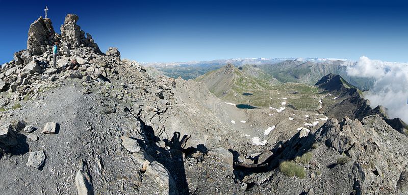
Bric Ghinivert or Eiminàl is a mountain of the Cottian Alps located in Italy. ()
PiedmontItaly
Bric Ghinivert plan & book
Unleash the traveler in you — discover the cheapest flight deals, find the perfect hotel or hostel nearby, and search for the best car rental prices. Travel at your own pace to discover new places and enjoy your journey.
Bric Ghinivert – popular in the area (distance from the attraction)
Nearby attractions include: Via Lattea, Fenestrelle Fort, Monte Albergian, Rognosa di Sestriere.
5.4 miWWinter sport, Ski areaVia Lattea, Sestriere
138 min walk • The Via Lattea is a winter sports area in the Italian and French Alps, straddling the French-Italian border at Claviere/Montgenèvre.
6.4 miNECity wall, Historical place, History museumFenestrelle Fort
164 min walk • Nestled in the Italian Alps, Fenestrelle Fort is a monumental example of military architecture and one of the largest fortifications in Europe. Spanning over 1,300 meters in elevation, this colossal structure was built between 1728 and 1850 to defend the Kingdom of...
3.9 miNNature, Natural attraction, MountainMonte Albergian
99 min walk • Monte Albergian is a 3,041 m a.s.l. mountain of the Cottian Alps, located in Italy. A battalion of 3rd Alpini Regiment, which during World War I earned a Silver Medal of Military Valor, was named after Monte Albergian.
3.2 miWNature, Natural attraction, MountainRognosa di Sestriere
81 min walk • Rognosa di Sestriere is a mountain of the Cottian Alps in Piedmont, Italy.
1.7 miSWParkParco naturale Val Troncea
44 min walk • The nature park Parco naturale Val Troncea is located in Val Chisone, municipality of Pragelato in the Metropolitan City of Turin. The park was created in 1980 to preserve the natural environment.
3.1 miNENature, Natural attraction, MountainMonte Politri
79 min walk • Monte Politri or Bric Rosso is a 3,026 m a.s.l. mountain of the Cottian Alps, located in Italy.
5.5 miWNature, Natural attraction, Mountain passColle Sestriere, Sestriere
140 min walk • Colle Sestriere, Col de Sestriere, is a mountain pass in the Cottian Alps. It is occupied by the town of Sestriere in the Province of Turin, Italy. It is 17 km from the French border. Its name derives from Latin: ad petram sistrariam, that is at sixty Roman miles from Turin.
4.9 miNWLocalityPragelato
126 min walk • Pragelato is a comune in the Metropolitan City of Turin in the Italian region Piedmont, located about 60 kilometres west of Turin, in the upper Val Chisone.
1.9 miWAlpine hut, HikingRifugio Troncea
49 min walk • The Troncea refuge is a refuge located in the municipality of Pragelato, in the Troncea valley in the Cottian Alps, at 1,915 m above sea level.