Rifugio Mandrone
#5985 among destinations in Italy
![Rifugio Mandrone location map](https://tzmedia.b-cdn.net/media/images/static-maps/it/46_2026_10_5712.jpg)
Facts and practical information
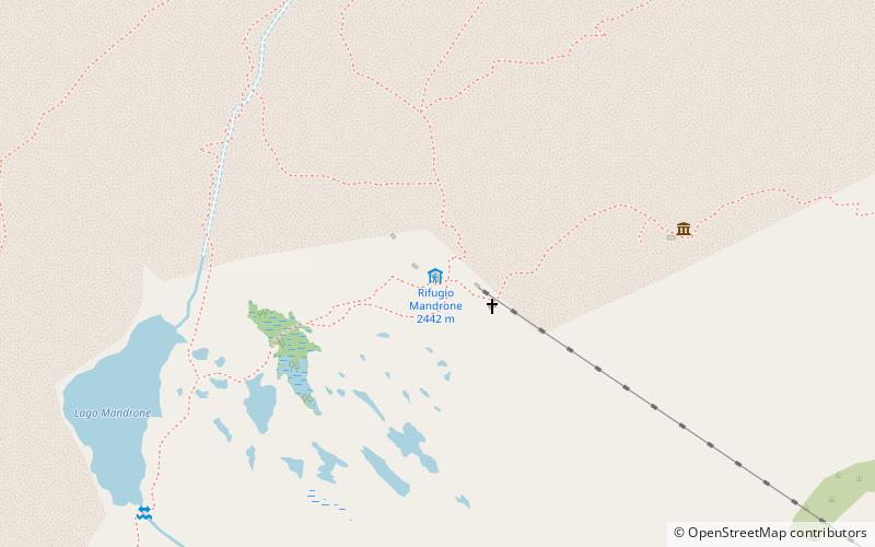
The "City of Trento" refuge at Mandrone is located in the Mandrone basin, in the Adamello group, at 2449 m a.s.l. in the territory of the municipality of Spiazzo, in the Genova valley.
Trentino-South TyrolItaly
Rifugio Mandrone plan & book
Unleash the traveler in you — discover the cheapest flight deals, find the perfect hotel or hostel nearby, and search for the best car rental prices. Travel at your own pace to discover new places and enjoy your journey.
Rifugio Mandrone – popular in the area (distance from the attraction)
Nearby attractions include: Mount Adamello, Presanella, Adamello-Presanella Alps, Tonale Pass.
4.8 miSWNature, Natural attraction, MountainMount Adamello
123 min walk • Mount Adamello is a majestic peak nestled in the heart of the Italian Alps, renowned for its imposing presence and breathtaking landscapes. At an elevation of 3,539 meters above sea level, it is one of the principal summits of the Adamello-Presanella range, which spans...
4.6 miENature, Natural attraction, MountainPresanella
118 min walk • Presanella is a mountain in the Adamello-Presanella range of the Italian Alps of northern Italy. Presanella has an elevation of 3,558 meters and is located in the Adamello Brenta National Park within the Trentino province of Italy.
4.3 miNENature, Natural attraction, Natural featureAdamello-Presanella Alps
109 min walk • The Adamello-Presanella Alps Alpine group is a mountain range in the Southern Limestone Alps mountain group of the Eastern Alps. It is located in northern Italy, in the provinces of Trentino and Brescia. The name stems from its highest peaks: Adamello and Presanella.
3.8 miNMountain pathway popular with hikersTonale Pass
98 min walk • Tonale Pass is a high mountain pass in northern Italy across the Rhaetian Alps, between Lombardy and Trentino. It connects Valcamonica and Val di Sole. It is delimited by the Ortler Alps to the north and the Adamello range to the south.
6.3 miNEMuseumForte Strino - Werk Strino
162 min walk • Fort Strino is an Austro-Hungarian fort, belonging to the large system of Austrian fortifications on the Italian border, located near the Tonale Pass, in the municipal territory of Vermiglio, Trentino.
6.4 miSWAlpine hut, HikingRifugio Paolo Prudenzini
163 min walk • The Paolo Prudenzini refuge is a refuge located in the municipality of Saviore dell'Adamello, in the Camonica valley, at 2,235 m a.s.l. It rises at the foot of the Adamello, located at the head of the Salarno valley.
4 miSWAlpine hut, HikingRifugio Giuseppe Garibaldi
102 min walk • In Italy there are several mountain huts named after Giuseppe Garibaldi: Rifugio Giuseppe Garibaldi - located in Val Camonica, Rifugio Giuseppe Garibaldi - located in Gran...
2.4 miSAlpine hut, HikingRifugio ai Caduti dell'Adamello
61 min walk • The refuge "Ai Caduti dell'Adamello" is located at 3040 m above sea level a short distance from Lobbia Alta Pass, on the southwest slope of Lobbia Alta, in the Adamello group, in the territory of the municipality of Spiazzo, in Val Rendena.
4.9 miNEAlpine hut, HikingRifugio Stavèl Francesco Denza
126 min walk • The Stavèl Francesco Denza refuge is an important alpine refuge of the SAT located at the foot of the moraine of the Presena glacier of the Presanella group, in the territory of Vermiglio, at an altitude of 2,298 m above sea level.