Hettstädt
#2796 among destinations in Germany
Facts and practical information
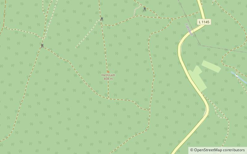
The Hettstädt is a mountain between Oberweißbach/Thür. Wald and Neuhaus am Rennweg. At 808 metres, it is one of the highest mountains in the Thuringian Highland. It is best accessed from the road between Cursdorf and Neuhaus am Rennweg. ()
ThuringiaGermany
Hettstädt – popular in the area (distance from the attraction)
Nearby attractions include: Rauhhügel, Leibis-Lichte Dam, Deesbach Forebay, Thuringian Highland.
3.6 miENature, Natural attraction, MountainRauhhügel
92 min walk • The Rauhhügel is an 812.9 m high mountain located in the Thuringian Highland, Thuringia. It is located close to the municipalities of Schmiedefeld and Lichte and the Leibis-Lichte Dam in the Saalfeld-Rudolstadt district in the Thuringian Forest Nature Park within walking distance of the Rennsteig.
3.8 miNEDamLeibis-Lichte Dam
97 min walk • The Leibis-Lichte Dam is a 102.5-metre-tall dam in the German state of Thuringia in the Thuringian Highland. The dam was completed in 2005 to impound the River Lichte, between the Lichte municipality section Geiersthal and Unterweissbach.
1.9 miNENature, Lake, Natural attractionDeesbach Forebay
50 min walk • The Deesbach Forebay is a dam in the German state of Thuringia in the Thuringian Highland. It impounds the river Lichte and lies between the municipalities Lichte and Unterweissbach. That particular forebay belongs to the Leibis-Lichte Dam.
3.8 miSNature, Natural attraction, ForestThuringian Highland, Lauscha
97 min walk • The Thuringian Highland, Thuringian Highlands or Thuringian-Vogtlandian Slate Mountains is a low range of mountains in the German state of Thuringia.
2.2 miSENature, Natural attraction, MountainRückersbiel
55 min walk • The Rückersbiel a 755.6 m high mountain located in the Thuringian Highland, Thuringia. It is located close to the municipality of Lichte and the Leibis-Lichte Dam in the Saalfeld-Rudolstadt district in the Thuringian Forest Nature Park.
2.9 miSENature, Natural attraction, MountainApelsberg
74 min walk • The Apelsberg is a 785.3 m high mountain located in the Thuringian Highland, Thuringia. It is located close to the municipality of Lichte and the Leibis-Lichte Dam in the Saalfeld-Rudolstadt district in the Thuringian Forest Nature Park.
2.4 miSENature, Natural attraction, MountainSauhügel
61 min walk • The Sauhügel is a 721.7 m high mountain located in the Thuringian Highland, Thuringia. It is located close to the municipality of Lichte and the Leibis-Lichte Dam in the Saalfeld-Rudolstadt district in the Thuringian Forest Nature Park within walking distance of the Rennsteig.
3.7 miEMuseumMorassina
96 min walk • Morassina is an inactive mine in Schmiedefeld, Thuringia, Germany. Today it is a tourist attraction known for its stalactites.
2.9 miENature, Natural attraction, MountainMutzenberg
76 min walk • The Mutzenberg is a 770.0 m high mountain located in the Thuringian Highland, Thuringia. It is to be found close to the municipality of Lichte, and the Leibis-Lichte Dam in the Saalfeld-Rudolstadt district in the Thuringian Forest Nature Park.
2.4 miENature, Natural attraction, MountainSpitzer Berg
62 min walk • The Spitzer Berg is a 790.3 m high mountain located in the Thuringian Highland, Thuringia. It is located close to the municipality of Lichte and the Leibis-Lichte Dam in the Saalfeld-Rudolstadt district in the Thuringian Forest Nature Park within walking distance of the Rennsteig.
4.3 miENature, Natural attraction, MountainAßberg
109 min walk • The Aßberg is a 703-m high mountain located in the Thuringian Highland region of Thuringia, Germany. It is located close to the municipalities of Deesbach, Meura, Reichmannsdorf, and Schmiedefeld and the Leibis-Lichte Dam in the Saalfeld-Rudolstadt district in the Thuringian Forest Nature Park.