Rifugio Rosetta "Giovanni Pedrotti", Dolomites
#26 among attractions in Dolomites
Facts and practical information
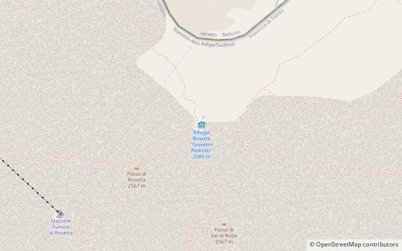
The Giovanni Pedrotti Refuge is located on the Rosetta Plateau in the Pale di San Martino Mountains at an elevation of 2,581 meters above sea level.
Dolomites plan & book
Unleash the traveler in you — discover the cheapest flight deals, find the perfect hotel or hostel nearby, and search for the best car rental prices. Travel at your own pace to discover new places and enjoy your journey.
Rifugio Rosetta "Giovanni Pedrotti" – popular in the area (distance from the attraction)
Nearby attractions include: Lago di Calaita, Cimon della Pala, Monte Agnèr, Rolle Pass.
- 4.9 miSWNature, Natural attraction, Lake
Lago di Calaita
126 min walk • Lago di Calaita, a serene alpine lake nestled in the picturesque setting of the Italian Dolomites, is a hidden gem waiting to be discovered. Surrounded by the verdant forests and the rugged peaks of the Lagorai chain, this tranquil body of water offers a respite from...
- 1.4 miNWNature, Natural attraction, Mountain
Cimon della Pala, Dolomites
36 min walk • Cimon della Pala, sometimes called Cimone and The Matterhorn of the Dolomites, is the best-known peak of the Pale di San Martino group, in the Dolomites, northern Italy.
- 5.5 miENature, Natural attraction, Mountain
Monte Agnèr, Dolomites
142 min walk • Monte Agnèr is a mountain of the Dolomites located near the village of Taibon Agordino in Belluno, northeast Italy. It lies in the Pala group and is known locally as Il Pizzòn, meaning Great Peak.
- 3.2 miNWNature, Natural attraction, Mountain pass
Rolle Pass
82 min walk • The Rolle Pass is a high mountain pass in Trentino in Italy. It connects the Fiemme and Primiero valleys, and the communities of Predazzo, San Martino di Castrozza and Fiera di Primiero.
- 1.8 miSENature, Natural attraction, Mountain
Vezzana, Dolomites
46 min walk • The Vezzana is the highest peak in the Pala group, a mountain range of the Dolomites, northern Italy. It is located in the northern part of the Dolomites, between the Taibon Agordino and Primiero comunes of Belluno and Trentino. It has an altitude of 3,192 metres.
- 1.3 miENature, Natural attraction, Natural feature
Pala group, Dolomites
34 min walk • The Pala group is the largest massif of the Dolomites, with about 240 km² of surface, located between eastern Trentino and Veneto, in the area between Primiero, Valle del Biois and Agordino.
- 5.5 miSForts and castles
Castel Pietra
139 min walk • Castel Pietra is a castle in Trentino, Italy, in the Primiero valley. It towers over the town of Tonadico, being located on an erratic boulder to the left of the state road to the Cereda Pass, at the mouth of the Val Canali.
- 3.3 miNNature, Natural attraction, Mountain
Monte Mulaz, Dolomites
86 min walk • Mulàz is a mountain in the Pale di San Martino Mountains, located in the Province of Belluno.
- 2.7 miNNature, Natural attraction, Mountain
Cima del Focobon, Dolomites
70 min walk • Cima del Focobon is a mountain in the Pale di San Martino, located in the Group of the same name in the Province of Belluno.
- 2.1 miN46°17'52"N • 11°49'55"E
Cima dei Bureloni, Dolomites
54 min walk • Nature, Natural attraction, Mountain
- 2.3 miSNature, Natural attraction, Mountain
Sass Maòr, Dolomites
59 min walk • Sass Maor is one of the most famous peaks in the Pale di San Martino and the entire Dolomites and, like the Three Peaks of Lavaredo, a monument to the history of mountaineering in the Dolomites.