Foostock
#2003 among destinations in Switzerland
![Foostock location map](https://tzmedia.b-cdn.net/media/images/static-maps/ch/46_9565_9_24467.jpg)
Facts and practical information
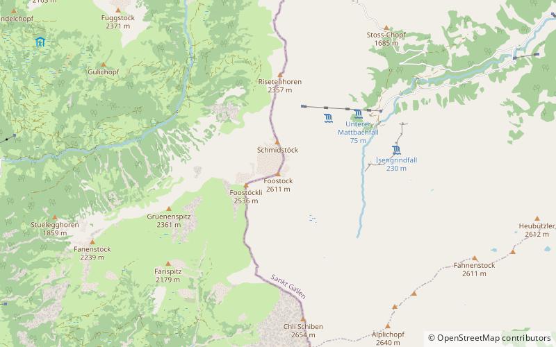
The Foostock, also known as the Ruchen, is a mountain of the Glarus Alps, located on the border between the Swiss cantons of Glarus and St. Gallen. It lies north of Piz Sardona, on the range that separates the Sernftal from the Weisstannental. ()
Sankt GallenSwitzerland
Foostock plan & book
Unleash the traveler in you — discover the cheapest flight deals, find the perfect hotel or hostel nearby, and search for the best car rental prices. Travel at your own pace to discover new places and enjoy your journey.
Foostock – popular in the area (distance from the attraction)
Nearby attractions include: Spitzmeilen, Piz Dolf, Ringelspitz, Laaxer Stöckli.
4.7 miNNature, Natural attraction, MountainSpitzmeilen
120 min walk • The Spitzmeilen is a mountain of the Glarus Alps, lying on the border between the Swiss cantons of Glarus and St. Gallen. It lies between the valleys of Schilstal and Sernftal.
3.8 miSNature, Natural attraction, MountainPiz Dolf
98 min walk • Piz Dolf or Trinserhorn is a mountain of the Glarus Alps, located on the border between the cantons of St. Gallen and Graubünden. Piz Sardona is to the north across a glacier, and to its west Piz Segnas. Both Piz Segnas and Piz Dolf show the line of the Glarus thrust in its upper part.
6.1 miSENature, Natural attraction, MountainRingelspitz
157 min walk • The Ringelspitz is a mountain of the Glarus Alps, located on the border between the Swiss cantons of St. Gallen and Graubünden. Reaching a height of 3,248 metres above sea level, it is the highest summit in the canton of St. Gallen. It is split between three municipalities: Pfäfers, Trin and Tamins.
5.4 miSNature, Natural attraction, MountainLaaxer Stöckli
139 min walk • The Laaxer Stöckli is a 2,898 metre-high mountain of the Glarus Alps, located on the border between the cantons of Glarus and Graubünden in Eastern Switzerland. It lies approximately halfway between the Vorab and Piz Segnas.
2.5 miSNature, Natural attraction, MountainPiz Sardona
64 min walk • Piz Sardona is a mountain in the Glarus Alps, on the border between the cantons Glarus and St. Gallen. The 3,056 metre high mountain overlooks the valleys of Elm and Calfeisen.
3.4 miSNature, Natural attraction, MountainPiz Segnas
86 min walk • Piz Segnas is a mountain in the Glarus Alps, located on the border between the cantons of Glarus and Graubünden. Piz Sardona is on the same ridge to the north, from where the Trinserhorn or Piz Dolf lies to the southeast.
6.6 miNWNature, Natural attraction, MountainGufelstock
169 min walk • The Gufelstock is a mountain of the Glarus Alps, overlooking Schwanden in the canton of Glarus. The border with the canton of St. Gallen runs on the northern base of the mountain.
5.9 miNENature, Natural attraction, MountainHochfinsler
151 min walk • The Hochfinsler is a mountain of the Glarus Alps, located south of Flums in the canton of St. Gallen. It lies on the range north of the Wissgandstöckli, that separates the Schilstal from the Weisstannental.
5.4 miNNature, Natural attraction, MountainMagerrain
138 min walk • The Magerrain is a mountain of the Glarus Alps, located on the border between the cantons of Glarus and St. Gallen in Eastern Switzerland.
5.9 miNWNature, Natural attraction, MountainBützistock
151 min walk • The Bützistock is a mountain of the Glarus Alps. It lies on the border between the cantons of Glarus and St. Gallen in Eastern Switzerland. The top is 2,496 m above sea level or 513 meters above the surrounding terrain. The width at the base is 18 km.
5.4 miWNature, Natural attraction, LakeChüebodensee
138 min walk • Chüebodensee is a lake above Elm in the Canton of Glarus, Switzerland. Its surface area is 1.4 ha. There are about 8 km of well established trails around the lake. The lake is within the Glarner Freiberg wildlife preserve.