Monte Buio
#729 among destinations in Italy
![Monte Buio location map](https://tzmedia.b-cdn.net/media/images/static-maps/it/44_5821_9_11145.jpg)
Facts and practical information
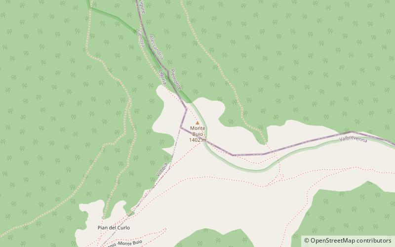
Monte Buio is a mountain in Liguria, northern Italy, part of the Ligurian Appennines. It is located between the provinces of Genoa and Alessandria. It lies at an altitude of 1400 metres. ()
LiguriaItaly
Monte Buio plan & book
Unleash the traveler in you — discover the cheapest flight deals, find the perfect hotel or hostel nearby, and search for the best car rental prices. Travel at your own pace to discover new places and enjoy your journey.
Monte Buio – popular in the area (distance from the attraction)
Nearby attractions include: Monte Antola, Lago del Brugneto, Monte Carmo, Monte delle Tre Croci.
2 miENature, Natural attraction, MountainMonte Antola
50 min walk • Nestled in the heart of the Ligurian Apennines in Italy, Monte Antola is a mountain that offers a tranquil escape from the bustling cities. Standing at an elevation of 1,597 meters, it is a popular destination for hikers and nature enthusiasts seeking to immerse...
4.9 miSENature, Natural attraction, LakeLago del Brugneto
125 min walk • Lago del Brugneto is a lake in the Province of Genova, Liguria, Italy. At an elevation of 775.8 m, its surface area is 0.97 km².
4.9 miNENature, Natural attraction, MountainMonte Carmo
126 min walk • Monte Carmo is a mountain in the Ligurian Apennine, northern Italy.
3 miENature, Natural attraction, MountainMonte delle Tre Croci
76 min walk • Monte delle Tre Croci is a mountain on the border between Liguria and Piedmont, northern Italy, part of the Ligurian Appennines. It has a summit elevation of 1,565 metres.
2 miNNature, Natural attraction, Mountain passValico di San Fermo
50 min walk • Valico di San Fermo also called Valico di San Clemente is a mountain pass between province of Genoa and province of Alessandria in Italy. It connects the Borbera and Vobbia valley, linking Cabella Ligure and Vobbia in the south.
4.4 miWNature, Natural attraction, MountainRocche del Reopasso, Crocefieschi
113 min walk • Rocche del Reopasso is a mountain in Liguria, northern Italy, part of the Ligurian Appennines.
5 miSEChurchChiesa di Sant'Onorato, Torriglia
127 min walk • The church of Sant'Onorato di Arles is a Catholic place of worship located in the municipality of Torriglia, in Piazza della Chiesa, in the metropolitan city of Genoa. The church is the seat of the parish of the same name of the Genovesato...
5.3 miSENature, Natural attraction, MountainMonte Prelà, Torriglia
135 min walk • Monte Prelà is a mountain in Liguria, northern Italy, part of the Ligurian Appennines.
5.2 miNWForts and castlesCastello della Pietra, Vobbia
133 min walk • The Stone Castle is an ancient fortification located in the Ligurian municipality of Vobbia, situated in the valley of the same name tributary to the Scrivia stream. It is the main and most characteristic monument of the Genoa hinterland, a...
5.7 miNWNature, Natural attraction, MountainBric delle Camere
146 min walk • Bric delle Camere is a mountain in northern Italy, part of the Ligurian Appennines. It is located in the provinces of Genoa and Alessandria. It lies at an altitude of 1016 metres.
3.7 miSWChurchChiesa del Santissimo Nome di Maria
96 min walk • The Church of the Most Holy Name of Mary is a Catholic place of worship located in the hamlet of Frassinello in the municipality of Valbrevenna, in the metropolitan city of Genoa. The church is the seat of the parish of the same name of the Scrivia...