Monte delle Tre Croci
#775 among destinations in Italy
![Monte delle Tre Croci location map](https://tzmedia.b-cdn.net/media/images/static-maps/it/44_586_9_17161.jpg)
Facts and practical information
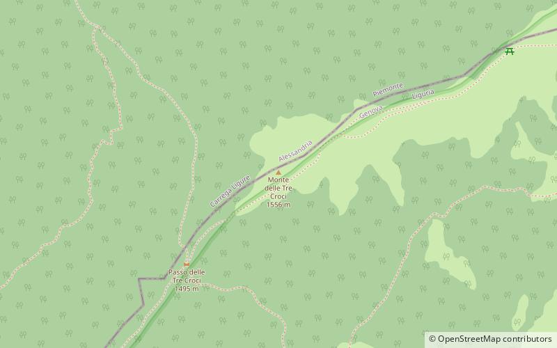
Monte delle Tre Croci is a mountain on the border between Liguria and Piedmont, northern Italy, part of the Ligurian Appennines. It has a summit elevation of 1,565 metres. ()
LiguriaItaly
Monte delle Tre Croci plan & book
Unleash the traveler in you — discover the cheapest flight deals, find the perfect hotel or hostel nearby, and search for the best car rental prices. Travel at your own pace to discover new places and enjoy your journey.
Monte delle Tre Croci – popular in the area (distance from the attraction)
Nearby attractions include: Monte Antola, Lago del Brugneto, Monte Carmo, Monte Buio.
1.4 miSWNature, Natural attraction, MountainMonte Antola
35 min walk • Nestled in the heart of the Ligurian Apennines in Italy, Monte Antola is a mountain that offers a tranquil escape from the bustling cities. Standing at an elevation of 1,597 meters, it is a popular destination for hikers and nature enthusiasts seeking to immerse...
3.3 miSNature, Natural attraction, LakeLago del Brugneto
84 min walk • Lago del Brugneto is a lake in the Province of Genova, Liguria, Italy. At an elevation of 775.8 m, its surface area is 0.97 km².
2.5 miNENature, Natural attraction, MountainMonte Carmo
64 min walk • Monte Carmo is a mountain in the Ligurian Apennine, northern Italy.
3 miWNature, Natural attraction, MountainMonte Buio
76 min walk • Monte Buio is a mountain in Liguria, northern Italy, part of the Ligurian Appennines. It is located between the provinces of Genoa and Alessandria. It lies at an altitude of 1400 metres.
3.7 miNWNature, Natural attraction, Mountain passValico di San Fermo
96 min walk • Valico di San Fermo also called Valico di San Clemente is a mountain pass between province of Genoa and province of Alessandria in Italy. It connects the Borbera and Vobbia valley, linking Cabella Ligure and Vobbia in the south.
5.9 miNENature, Natural attraction, MountainMonte Alfeo
150 min walk • Monte Alfeo is a mountain in the Ligurian Apennine, located in the territory of the commune of Ottone, province of Piacenza, central Italy, in the left bank of the Val Trebbia. Having an altitude of 1,651 m, it is part of the Monte Antola group.
4.7 miSChurchChiesa di Sant'Onorato, Torriglia
120 min walk • The church of Sant'Onorato di Arles is a Catholic place of worship located in the municipality of Torriglia, in Piazza della Chiesa, in the metropolitan city of Genoa. The church is the seat of the parish of the same name of the Genovesato...
4.8 miSNature, Natural attraction, MountainMonte Prelà, Torriglia
123 min walk • Monte Prelà is a mountain in Liguria, northern Italy, part of the Ligurian Appennines.
4.7 miNWNature, Natural attraction, MountainMonte Castello
119 min walk • Monte Castello is a mountain in Liguria, northern Italy, part of the Ligurian Appennines. It is located in the provinces of Genoa and Alessandria. It lies at an altitude of 1092 metres.
3.5 miSEChurchSaint Michael the Archangel Church
90 min walk • The Church of Saint Michael Archangel is a Catholic place of worship located in the hamlet of Carpeneto in the municipality of Fascia, in the metropolitan city of Genoa. The church is the seat of the parish of the same name of the Genovesato...
6.6 miNWLocalityMongiardino Ligure
168 min walk • Mongiardino Ligure is a comune in the Province of Alessandria in the Italian region Piedmont, located about 120 kilometres southeast of Turin and about 50 kilometres southeast of Alessandria.