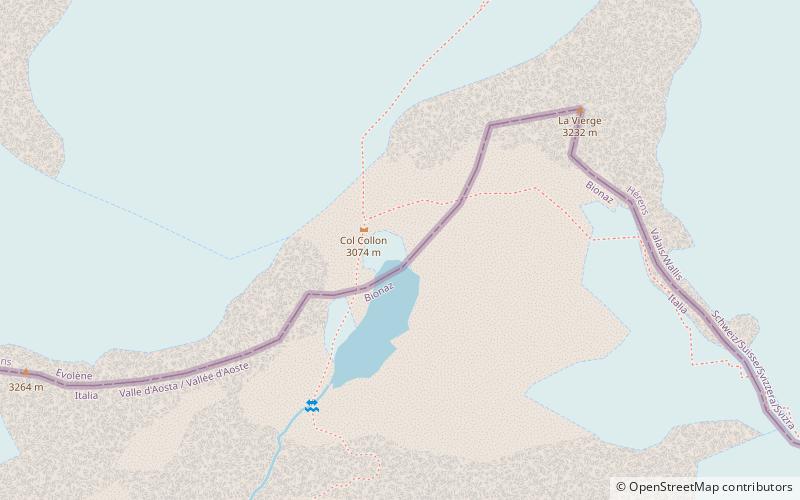
Col Collon
#3708 among destinations in Italy
Facts and practical information
Aosta ValleyItaly
Col Collon plan & book
Unleash the traveler in you — discover the cheapest flight deals, find the perfect hotel or hostel nearby, and search for the best car rental prices. Travel at your own pace to discover new places and enjoy your journey.
Col Collon – popular in the area (distance from the attraction)
Nearby attractions include: Refuge Prarayer, Refuge Nacamuli au col Collon, Dent d'Hérens, Tête Blanche.
- 2.9 miSHiking, Mountain hut, Alpine hut
Refuge Prarayer, Bionaz
74 min walk • Refuge Prarayer is a refuge in the Alps in Aosta Valley, Italy, at an altitude of 2005 metres.
- 1.1 miSWHiking, Alpine hut
Refuge Nacamuli au col Collon, Bionaz
28 min walk • Refuge Nacamuli au col Collon is a refuge in the Alps in Aosta Valley, Italy.
- 4.4 miEMountain with views of the Matterhorn
Dent d'Hérens, Breuil-Cervinia
113 min walk • The Dent d'Hérens is a mountain in the Pennine Alps, lying on the border between Italy and Switzerland. The mountain lies a few kilometres west of the Matterhorn. The Aosta hut is used for the normal route.
- 3.4 miNENature, Natural attraction, Mountain
Tête Blanche
88 min walk • Tête Blanche is a mountain of the Pennine Alps on the Swiss-Italian border. Its summit is the tripoint between the valleys of Hérens, Mattertal and Valpelline, thus forming the linguistic tri-point between French, German, and Italian-speaking areas.
- 2.4 miEHiking, Alpine hut
Refuge Aoste
60 min walk • Refuge Aoste is a mountain hut in the Valpelline, in the Pennine Alps, owned by the Club Alpino Italiano. It is in the commune of Bionaz, Aosta Valley, Italy.
- 4.4 miSDam
Place Moulin Dam
111 min walk • Place Moulin Dam is one of the largest dams in Europe and is in Bionaz, in Northern Italy. The 678 m long and 155 m high arch dam was constructed between 1955 and 1965 and has an artificial reservoir capable of holding 105 million sq m of water.
- 2.3 miSWNature, Natural attraction, Mountain
La Singla
58 min walk • La Singla, also spelled La Sengla, is a 3,714 m mountain of the Pennine Alps, located on the border between Switzerland and Italy. It is the highest summit lying between the valleys of Bagnes and Valpelline. On its northern side La Singla overlooks the Otemma Glacier.
- 5.2 miENature, Natural attraction, Mountain
Punta Maria Cristina, Breuil-Cervinia
132 min walk • The Punta Maria Cristina is a mountain of the Pennine Alps, located on the Swiss-Italian border. It lies on the main Alpine watershed, between the Dent d'Hérens and the Matterhorn.
- 1.2 miENature, Natural attraction, Mountain
Mont Brulé
32 min walk • Mont Brulé is a mountain of the Pennine Alps, located on the Swiss-Italian border, east of the Col Collon. On its northern side it overlooks the upper Arolla Glacier.
- 4 miSWNature, Natural attraction, Mountain
Aouille Tseuque
102 min walk • Aouille Tseuque is a mountain of the Pennine Alps on the Swiss-Italian border. On its northern side it overlooks the Otemma Glacier.
- 4.2 miENature, Natural attraction, Mountain
Punta Lioy, Breuil-Cervinia
107 min walk • Punta Lioy is a 3816 m above sea level mountain in the Pennine Alps, in the Aosta Valley. It is part of the Grandes Murailles, on the watershed between Valpelline and Valtournenche.